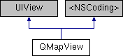
地图view 更多...
#import <QMapView.h>
构造函数 | |
| (void) | - setCenterCoordinate:animated: |
| 设定地图中心点经纬度 更多... | |
| (id) | - initWithFrame: |
| 初始化场景地图 更多... | |
| (void) | - setRegion:animated: |
| 设定当前地图的region 更多... | |
| (void) | - setVisibleMapRect:animated: |
| 设置当前地图可见范围的mapRect 更多... | |
| (void) | - setVisibleMapRect:edgePadding:animated: |
| 设置当前地图可见范围的mapRect 更多... | |
| (QCoordinateRegion) | - regionThatFits: |
| 根据当前地图视图frame的大小调整region范围,返回适合当前地图frame的region,调整过程中当前地图的中心点不会改变 更多... | |
| (QMapRect) | - mapRectThatFits: |
| 调整mapRect使其适合地图窗口显示的范围 更多... | |
| (QMapRect) | - mapRectThatFits:edgePadding: |
| 调整mapRect使其适合地图窗口显示的范围 更多... | |
| (void) | - setDisplayLauguage: |
| 指定底图文字显示的首选语言 更多... | |
| (void) | - setZoomLevel:animated: |
| 设置当前地图缩放级别 更多... | |
| (void) | - setCenterCoordinate:zoomLevel:animated: |
| 同时设置中心点与缩放级别 更多... | |
| (CGPoint) | - convertCoordinate:toPointToView: |
| 将经纬度坐标转化为相对于指定view的坐标 更多... | |
| (CLLocationCoordinate2D) | - convertPoint:toCoordinateFromView: |
| 将相对于view的坐标转化为经纬度坐标 更多... | |
| (CGRect) | - convertRegion:toRectToView: |
| 将地图上的region转化为相对于view的rectangle 更多... | |
| (QCoordinateRegion) | - convertRect:toRegionFromView: |
| 将相对于view的rectangle转化为region 更多... | |
| (void) | - addAnnotation: |
| 向地图窗口添加标注,需要实现QMapViewDelegate的-mapView:viewForAnnotation:函数来生成标注对应的View 更多... | |
| (void) | - addAnnotations: |
| 向地图窗口添加一组标注,需要实现QMapViewDelegate的-mapView:viewForAnnotation:函数来生成标注对应的View 更多... | |
| (void) | - removeAnnotation: |
| 移除标注 更多... | |
| (void) | - removeAnnotations: |
| 移除一组标注 更多... | |
| (QAnnotationView *) | - viewForAnnotation: |
| 获取指定标注的view 更多... | |
| (NSSet *) | - annotationsInMapRect: |
| 获取指定投影矩形范围内的标注 更多... | |
| (QAnnotationView *) | - dequeueReusableAnnotationViewWithIdentifier: |
| 从复用内存池中获取制定复用标识的annotationView 更多... | |
| (void) | - selectAnnotation:animated: |
| 选中标注对应的view 更多... | |
| (void) | - deselectAnnotation:animated: |
| 取消选中标注对应的view 更多... | |
| (void) | - showAnnotations:animated: |
| 设置地图使其可以显示数组中所有的标注 更多... | |
| (void) | - setUserTrackingMode:animated: |
| 设置追踪用户位置的模式 更多... | |
| (void) | - addOverlay: |
| 向地图窗口添加overlay,需要实现QMapViewDelegate的-mapView:viewForOverlay:函数来生成标注对应的view 更多... | |
| (void) | - addOverlays: |
| 向地图窗口添加一组overlay,需要实现QMapViewDelegate的-mapView:viewForOverlay:函数来生成标注对应的view 更多... | |
| (void) | - removeOverlay: |
| 移除overlay 更多... | |
| (void) | - removeOverlays: |
| 移除一组overlay 更多... | |
| (void) | - insertOverlay:atIndex: |
| 在指定的索引出添加一个overlay 更多... | |
| (void) | - exchangeOverlayAtIndex:withOverlayAtIndex: |
| 交换指定索引处的overlay 更多... | |
| (void) | - insertOverlay:aboveOverlay: |
| 在指定的overlay之上插入一个overlay 更多... | |
| (void) | - insertOverlay:belowOverlay: |
| 在指定的overlay之下插入一个overlay 更多... | |
| (QOverlayView *) | - viewForOverlay: |
| 查找指定overlay对应的View,如果该view尚未创建,返回nil 更多... | |
| (UIImage *) | - takeSnapshotInRect: |
| 在指定区域内截图 更多... | |
| (void) | - takeSnapshotInRect:withCompletionBlock: |
| 在指定区域内截图(异步) 更多... | |
属性 | |
| id< QMapViewDelegate > | delegate |
| 地图view的delegate | |
| QMapType | mapType |
| 地图类型 | |
| BOOL | showTraffic |
| 是否显示交通, 默认为NO | |
| BOOL | scrollEnabled |
| 是否支持平移, 默认为YES | |
| BOOL | zoomEnabled |
| 是否支持缩放, 默认为YES | |
| BOOL | keepCenterEnabled |
| pinch时保持中心点, 默认为NO | |
| BOOL | showsScale |
| 是否显示比例尺,默认为YES | |
| CLLocationCoordinate2D | centerCoordinate |
| 当前地图的中心点经纬度坐标,改变该值时,地图缩放级别不会发生变化 | |
| QCoordinateRegion | region |
| 当前地图的经纬度范围,设定的该范围可能会被调整为适合地图窗口显示的范围 | |
| QMapRect | visibleMapRect |
| 当前地图可见范围的mapRect | |
| double | zoomLevel |
| 地图缩放级别 | |
| double | minZoomLevel |
| 最小缩放级别 | |
| double | maxZoomLevel |
| 最大缩放级别 | |
| NSArray * | annotations |
| 当前地图上的标注数组 | |
| CGRect | annotationVisibleRect |
| 标注的可见区域 | |
| NSArray * | selectedAnnotations |
| 处于选中状态的标注数据数据(其count == 0 或 1) | |
| BOOL | showsUserLocation |
| 是否显示用户位置 | |
| CLLocationDistance | distanceFilter |
| 最小移动距离(单位是米), 当大于该值时定位回调才触发, 默认为kCLDistanceFilterNone | |
| QUserLocation * | userLocation |
| 当前用户位置数据 | |
| BOOL | forceUpdatingHeading |
| 是否强制开启heading 更新, 默认为NO. | |
| QUserTrackingMode | userTrackingMode |
| 定位用户位置的模式 | |
| BOOL | userLocationVisible |
| 当前位置在地图中是否可见 | |
| NSArray * | overlays |
| 当前地图上的overlay数组 | |
详细描述
地图view
函数文档
◆ addAnnotation:()
| - (void) addAnnotation: | (id< QAnnotation >) | annotation |
向地图窗口添加标注,需要实现QMapViewDelegate的-mapView:viewForAnnotation:函数来生成标注对应的View
- 参数
-
annotation 要添加的标注
◆ addAnnotations:()
| - (void) addAnnotations: | (NSArray *) | annotations |
向地图窗口添加一组标注,需要实现QMapViewDelegate的-mapView:viewForAnnotation:函数来生成标注对应的View
- 参数
-
annotations 要添加的标注数组
◆ addOverlay:()
| - (void) addOverlay: | (id< QOverlay >) | overlay |
向地图窗口添加overlay,需要实现QMapViewDelegate的-mapView:viewForOverlay:函数来生成标注对应的view
- 参数
-
overlay 要添加的overlay
由 category QMapView(OverlaysAPI) 提供.
◆ addOverlays:()
| - (void) addOverlays: | (NSArray *) | overlays |
向地图窗口添加一组overlay,需要实现QMapViewDelegate的-mapView:viewForOverlay:函数来生成标注对应的view
- 参数
-
overlays 要添加的overlay数组
由 category QMapView(OverlaysAPI) 提供.
◆ annotationsInMapRect:()
| - (NSSet *) annotationsInMapRect: | (QMapRect) | mapRect |
获取指定投影矩形范围内的标注
- 参数
-
mapRect 投影矩形范围
- 返回
- 标注集合
◆ convertCoordinate:toPointToView:()
| - (CGPoint) convertCoordinate: | (CLLocationCoordinate2D) | coordinate | |
| toPointToView: | (UIView *) | view | |
将经纬度坐标转化为相对于指定view的坐标
- 参数
-
coordinate 要转化的经纬度坐标 view point所基于的view
- 返回
- 源经纬度在目标view上的坐标
◆ convertPoint:toCoordinateFromView:()
| - (CLLocationCoordinate2D) convertPoint: | (CGPoint) | point | |
| toCoordinateFromView: | (UIView *) | view | |
将相对于view的坐标转化为经纬度坐标
- 参数
-
point 要转化的坐标 view point所基于的view
- 返回
- 源point转化后的经纬度
◆ convertRect:toRegionFromView:()
| - (QCoordinateRegion) convertRect: | (CGRect) | rect | |
| toRegionFromView: | (UIView *) | view | |
将相对于view的rectangle转化为region
- 参数
-
rect 要转化的rectangle view rectangle所基于的view
- 返回
- 转化后的region
◆ convertRegion:toRectToView:()
| - (CGRect) convertRegion: | (QCoordinateRegion) | region | |
| toRectToView: | (UIView *) | view | |
将地图上的region转化为相对于view的rectangle
- 参数
-
region 要转化的region view rectangle所基于的view
- 返回
- 转化后的rectangle
◆ dequeueReusableAnnotationViewWithIdentifier:()
| - (QAnnotationView *) dequeueReusableAnnotationViewWithIdentifier: | (NSString *) | identifier |
从复用内存池中获取制定复用标识的annotationView
- 参数
-
identifier 复用标识
- 返回
- 一个标注view
◆ deselectAnnotation:animated:()
| - (void) deselectAnnotation: | (id< QAnnotation >) | annotation | |
| animated: | (BOOL) | animated | |
取消选中标注对应的view
- 参数
-
annotation 选择的标注 animated 是否采用动画
◆ exchangeOverlayAtIndex:withOverlayAtIndex:()
| - (void) exchangeOverlayAtIndex: | (NSUInteger) | index1 | |
| withOverlayAtIndex: | (NSUInteger) | index2 | |
◆ initWithFrame:()
| - (id) initWithFrame: | (CGRect) | frame |
初始化场景地图
- 参数
-
frame 设定的地图view框
◆ insertOverlay:aboveOverlay:()
| - (void) insertOverlay: | (id< QOverlay >) | overlay | |
| aboveOverlay: | (id< QOverlay >) | sibling | |
在指定的overlay之上插入一个overlay
- 参数
-
overlay 待添加的overlay sibling 用于指定位置的overlay
由 category QMapView(OverlaysAPI) 提供.
◆ insertOverlay:atIndex:()
| - (void) insertOverlay: | (id< QOverlay >) | overlay | |
| atIndex: | (NSUInteger) | index | |
◆ insertOverlay:belowOverlay:()
| - (void) insertOverlay: | (id< QOverlay >) | overlay | |
| belowOverlay: | (id< QOverlay >) | sibling | |
在指定的overlay之下插入一个overlay
- 参数
-
overlay 待添加的overlay sibling 用于指定位置的overlay
由 category QMapView(OverlaysAPI) 提供.
◆ mapRectThatFits:()
调整mapRect使其适合地图窗口显示的范围
- 参数
-
mapRect 需要调整的mapRect
- 返回
- 调整后的mapRect
◆ mapRectThatFits:edgePadding:()
| - (QMapRect) mapRectThatFits: | (QMapRect) | mapRect | |
| edgePadding: | (UIEdgeInsets) | insets | |
调整mapRect使其适合地图窗口显示的范围
- 参数
-
mapRect 需要调整的mapRect insets 要嵌入的边界
- 返回
- 调整后的mapRect
◆ regionThatFits:()
| - (QCoordinateRegion) regionThatFits: | (QCoordinateRegion) | region |
根据当前地图视图frame的大小调整region范围,返回适合当前地图frame的region,调整过程中当前地图的中心点不会改变
- 参数
-
region 需要调整的region
- 返回
- 调整后的region
◆ removeAnnotation:()
| - (void) removeAnnotation: | (id< QAnnotation >) | annotation |
移除标注
- 参数
-
annotation 要移除的标注
◆ removeAnnotations:()
| - (void) removeAnnotations: | (NSArray *) | annotations |
移除一组标注
- 参数
-
annotations 要移除的标注数组
◆ removeOverlay:()
| - (void) removeOverlay: | (id< QOverlay >) | overlay |
◆ removeOverlays:()
| - (void) removeOverlays: | (NSArray *) | overlays |
◆ selectAnnotation:animated:()
| - (void) selectAnnotation: | (id< QAnnotation >) | annotation | |
| animated: | (BOOL) | animated | |
选中标注对应的view
- 参数
-
annotation 选择的标注 animated 是否采用动画
◆ setCenterCoordinate:animated:()
| - (void) setCenterCoordinate: | (CLLocationCoordinate2D) | coordinate | |
| animated: | (BOOL) | animated | |
设定地图中心点经纬度
- 参数
-
coordinate 要设定的地图中心点经纬度 animated 是否采用动画
◆ setCenterCoordinate:zoomLevel:animated:()
| - (void) setCenterCoordinate: | (CLLocationCoordinate2D) | coordinate | |
| zoomLevel: | (double) | newZoomLevel | |
| animated: | (BOOL) | animated | |
同时设置中心点与缩放级别
- 参数
-
coordinate 要设定的地图中心点经纬度 newZoomLevel 目标缩放级别 animated 是否采用动画
◆ setDisplayLauguage:()
| - (void) setDisplayLauguage: | (QMapLanguage) | language |
指定底图文字显示的首选语言
指定后底图会尽量用指定语言显示底图标注的文字,默认采用英语
- 参数
-
lauguage 指定的语言
- 参见
- QMapLanguage
◆ setRegion:animated:()
| - (void) setRegion: | (QCoordinateRegion) | region | |
| animated: | (BOOL) | animated | |
设定当前地图的region
- 参数
-
region 要设定的地图范围,用经纬度的方式表示 animated 是否采用动画
◆ setUserTrackingMode:animated:()
| - (void) setUserTrackingMode: | (QUserTrackingMode) | mode | |
| animated: | (BOOL) | animated | |
设置追踪用户位置的模式
- 参数
-
mode 要使用的模式 animated 是否采用动画
◆ setVisibleMapRect:animated:()
| - (void) setVisibleMapRect: | (QMapRect) | mapRect | |
| animated: | (BOOL) | animated | |
设置当前地图可见范围的mapRect
- 参数
-
mapRect 目标mapRect animated 是否采用动画
◆ setVisibleMapRect:edgePadding:animated:()
| - (void) setVisibleMapRect: | (QMapRect) | mapRect | |
| edgePadding: | (UIEdgeInsets) | insets | |
| animated: | (BOOL) | animated | |
设置当前地图可见范围的mapRect
- 参数
-
mapRect 目标mapRect insets 要嵌入的边界 animated 是否采用动画
◆ setZoomLevel:animated:()
| - (void) setZoomLevel: | (double) | newZoomLevel | |
| animated: | (BOOL) | animated | |
设置当前地图缩放级别
- 参数
-
newZoomLevel 目标缩放级别 animated 是否采用动画
◆ showAnnotations:animated:()
| - (void) showAnnotations: | (NSArray *) | annotations | |
| animated: | (BOOL) | animated | |
设置地图使其可以显示数组中所有的标注
- 参数
-
annotations 需要显示的标注数组 animated 是否采用动画
◆ takeSnapshotInRect:()
| - (UIImage *) takeSnapshotInRect: | (CGRect) | rect |
◆ takeSnapshotInRect:withCompletionBlock:()
| - (void) takeSnapshotInRect: | (CGRect) | rect | |
| withCompletionBlock: | (void(^)(UIImage *resultImage, CGRect rect)) | block | |
◆ viewForAnnotation:()
| - (QAnnotationView *) viewForAnnotation: | (id< QAnnotation >) | annotation |
获取指定标注的view
- 参数
-
annotation 指定的标注
- 返回
- 该标注的view
◆ viewForOverlay:()
| - (QOverlayView *) viewForOverlay: | (id< QOverlay >) | overlay |
查找指定overlay对应的View,如果该view尚未创建,返回nil
- 参数
-
overlay 指定的overlay
- 返回
- 指定overlay的view
由 category QMapView(OverlaysAPI) 提供.
该类的文档由以下文件生成: